Membership renewals open for 2024 - Click here

Industry

ASEG WA Webinar: Pre-stack Depth Imaging: Challenges in exploration-scale volcanic geobody model-building in the Potiguar Basin, Brazil

Tuesday, November 10, 2020
1500 (AWST)
1600 (AWST)

Pre-stack Depth Imaging: Challenges in exploration-scale volcanic geobody model-building in the Potiguar Basin, Brazil

Rich Bartlett, Shearwater GeoServices

Register here: https://us02web.zoom.us/webinar/register/WN_PRBuo4cySDixmFf5QwTLMQ

The Potiguar Basin includes the largest oil-producing region in Equatorial Brazil, where production is from the syn-rift to transitional successions. The Pitu well in the deep-water offshore part of the basin found oil, gas and condensate at depths of 4,300m in Upper Aptian sands of the Alagamar and Pescada Formations.


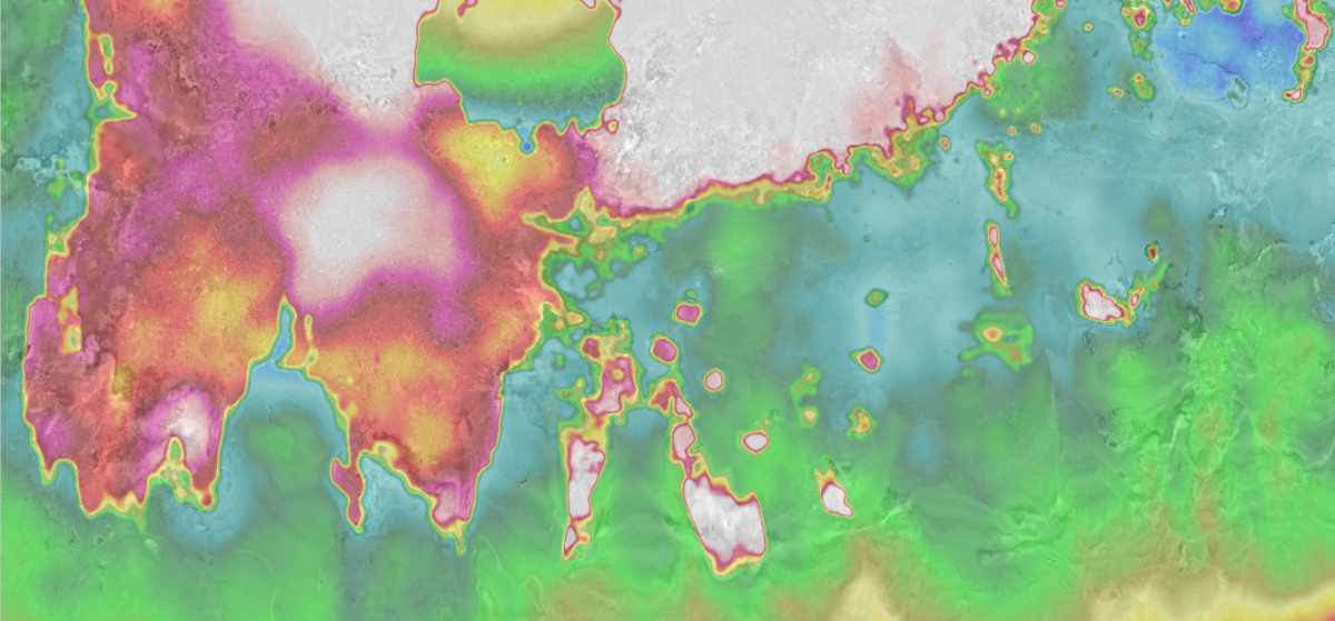
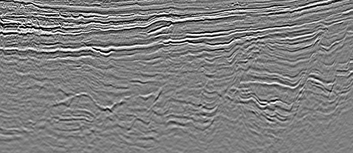
A 10,500 km² 3D survey was acquired in 2019 and seismic processing through PSDM imaging was initiated. The presence of high velocity volcanics in the sedimentary sequence presents unique imaging challenges for Pre-Stack Depth Migration (PSDM). By their nature, volcanic geobodies have a varying thickness, velocity fill and extent, and require detailed interpretation to be represented accurately in a PSDM anisotropic model. This talk will present an iterative and efficient methodology to interpret and refine volcanic geobodies with examples from this exploration-scale PSDM survey.


Rich Bartlett, Depth Imaging Manager from Shearwater GeoServices. Rich graduated in 2002 from the University of Leeds UK and Queen's University Canada with a Masters In Geophysics. He spent his early career as a Geophysicist at Veritas DGC with various roles in the Depth Imaging teams in both London and Calgary offices, moving through the various incarnations of CGGVeritas and CGG. This was followed by 3 years consulting with Monarch Geophysical Services on a range of marine and land acquisition and processing projects before moving back to the frontline with Dolphin Geophysical in 2013, and latterly with Shearwater GeoServices. Rich has helped build Shearwater's Depth Imaging capabilities from scratch, with Shearwater now offering a wide range of inversion and imaging services behind its vessels and to the open proprietary market.


Professional Development Course - Quieten your Inner Critic Workshop

Wednesday, November 11, 2020
1230 (AEST)
1430 (AEST)

Professional Development Course - Quieten your Inner Critic Workshop

Wednesday 11 November at 12.30-2.30pm AEST (Online)

To register, click here

Same cost as before: free for members, $25 for non-members.

We've explored how to break the cycle of feeling like a 'fake' at work. We've worked with the framework to be aware of that nagging voice in our head telling us that it was 'luck'. And we now know, we're not alone. What next?

With 70% of us experiencing 'impostor' like symptoms in our careers, this informative and inspiring interactive workshop sees us shift from an 'Impostor Life' to managing our 'Impostor Moments'. We'll balance our Inner Critic with our Wiser Self, build our evidence and re-energise our confidence to drive future success.

This workshop comes on the back of the popular course, Overcoming your Inner Critic, held in August. This workshop is a continuation, but if you didn't attend - IT'S OKAY - the facilitator will bring you up to speed. Cost is free for ASEG Members, $25 for non-members. Visit the ASEG Events page for further information, or click on the image below to watch the video...


ASEG Webinar - Stranded stream channels investigated by LiDAR mapping, some geophysics and good old leg work. Insights into the Lapstone Structural Complex west of Sydney.

Wednesday, October 21, 2020
1800 (AEST)
1900 (AEST)

Brought to you by NSW on Wednesday 21 October, 6pm (AEST) for a talk by Peter Hatherly.


Stranded stream channels investigated by LiDAR mapping, some geophysics and good old leg work. Insights into the Lapstone Structural Complex west of Sydney.


In the contemporary parlance, the western boundary of what the media call the Sydney Basin is the Lapstone Structural Complex. The front range of the Blue Mountains. This abrupt escarpment rises to a maximum height of 600 m above the Cumberland Plain and forms an impressive boundary to the Blue Mountains beyond.

Geologists identified the monoclines and faults associated with the LSC as early as the nineteenth century but an understanding of the exact nature of the structure and its timing is still not clear. In this talk I take note of evidence of stranded channels evident in detailed LiDAR mapping, the occurrence of river gravels now high above the Nepean River and seismic refraction results within the Thirlmere Lakes, a curious river system within the southern extension of the LSC.


My suggestion is that in its present form, the LSC is probably no older than 10 million years.


Register now: https://us02web.zoom.us/webinar/register/WN_klquuUL_Q3a39DbZUM-9rQ


The application of 2.5D AEM inversion to resource exploration with reference to open file survey examples from NSW, QLD and WA

Wednesday, September 16, 2020
1630 (AEST)
1730 (AEST)

The application of 2.5D AEM inversion to resource exploration with reference to open file survey examples from NSW, QLD and WA

The application of 2.5D AEM inversion to resource exploration.

The 2.5D AEM inversion technology developed by Intrepid produces spatially accurate images of subsurface conductivity in both cross section and in plan that are mostly free from the problems often seen in CDI and 1D inversions – particularly where 1D assumptions are not met.

Through a series of examples and survey configurations, we will demonstrate that 2.5D inversion products can be used confidently by geologists and geophysicists for orebody targeting and for geological and structural mapping in plan as well as in cross section. These products also facilitate the integrated interpretation of AEM, magnetics, gravity and surface geology.


Register now: https://us02web.zoom.us/webinar/register/WN_w83cseQ-RYKQ6K3HoZQamw


Webinar: Grayscale representative elementary volumes: An innovative approach to investigate pore-scale REVs from raw micro-CT images

Thursday, October 1, 2020
1200 (AWST)
1300 (AWST)

Title and Summary:

Grayscale representative elementary volumes: An innovative approach to investigate pore-scale REVs from raw micro-CT images

Representative Elementary Volumes (REVs) are at the foundation of measuring rock properties that capture local heterogeneities of the rock structure at a particular length-scale for upscaling purposes. High-resolution micro-computed tomography (micro-CT) images of rocks have allowed a full 3D characterization of rock structures at pore-scale. These micro-CT images store information about rock structure as variations in the gray-level intensities or CT numbers. However, the direct use of these information-rich raw micro-CT images for rock characterization has not been possible due to a limited number of rock properties that can be calculated from them. In this study, we implement a novel texture characterization technique called the Gray-level Size Zone Matrix (GLSZM) to analyze the raw micro-CT images. We apply the GLSZM approach to homogeneous and heterogeneous sandstones and carbonates and show that this method highlights important rock features such as mineralogical heterogeneities and sub-resolution porosity. Considering these features, we calculate GLSZM statistics, that serve as proxies to porosity and permeability, which are crucial petrophysical properties. Comparing the trends of these proxies to petrophysical properties at various scales and spatial locations of the rock sample, we then infer Grayscale REVs (GREVs) and validate it using existing literature. Finally, we show that using the GLSZM-based approach, we can infer GREVs in a robust, reproducible, and fast manner. These GREVs can then serve as a priori for further petrophysical characterization of rock samples. 

Bio:

Ankita Singh is a Ph.D. student at the School of Minerals and Energy Resources Engineering at UNSW, Sydney. Her work focusses on implementing texture analysis techniques for rock characterization by directly using raw x-ray images. Her Ph.D. work has been published in reputed journals such as Water Resources Research and Geophysical Research Letters. She also won the 'Best Engineering/Environmental Student Paper' at AEGC 2019 in Perth and was the 2019 Finalist at the UNSW Three Minute Thesis Competition. 

Register now: https://us02web.zoom.us/webinar/register/WN_gYxzak7oQ_y6-AE_JwdXEQ


AEGC 2021

Monday, September 13, 2021
0800
2000

AEGC 2021

Tuesday, September 14, 2021
0800
2000

On the cusp of a tear: continental subduction in the Banda arc

Tuesday, August 25, 2020
1430 (AEST)
1530 (AEST)

A new ASEG webinar brought to you by FedEx on Tuesday 25 August, 2:30pm (AEST) for a talk by Meghan Miller.

On the cusp of a tear:  continental subduction in the Banda arc

Eastward along the Sunda-Banda arc, convergence transitions from subduction of oceanic lithosphere to arc-continent collision. This region of eastern Indonesia and Timor-Leste provides an opportunity for unraveling the processes that occur during collision between a continent and a volcanic arc, and can be viewed as the temporal transition of the process of continental collision along strike.  We have collected a range of geological, geodetic, seismic, and geomorphic data to place constraints on the geometry and history of subduction. Utilizing ~4 years of new broadband seismic data we image the structure of the crust through to the mantle. Ambient noise tomography of the crust shows velocity anomalies along strike and across the arc, related to structure of the incoming Australian plate. The pattern of anomalies at depth resemble the system of salients and embayments that are present offshore western Australia, which formed during rifting of east Gondwana. At mantle depths, transition from oceanic subduction to continental collision appears reflected in new teleseismic based images, coinciding with previously identified changes in the geochemistry of the arc volcanics. Results from our body wave tomography show continuity of the subducting slab to depths of at least 300 km, with no evidence for tearing at the scale of >~50 km even in the region of arc-continent collision. Our expanded catalogue of Benioff zone seismicity reveals earthquakes in what was previously thought to be a seismic gap (the Wetar gap). Together, our seismic results suggest that tearing is not as advanced in this region as previously hypothesized, implying sustained subduction of continental lithosphere underneath the Banda arc. We suggest the tectonic evolution of this region is defined by inherited structure of the Gondwana rifted continental margin of the incoming plate.  Altogether, we suggest that this region is characterized by subduction of continental lithosphere poised for tearing that has perhaps just initiated, but with no large slab windows. Therefore, the initial template of plate structure controls orogenesis and deep mantle structure.

Register now: https://us02web.zoom.us/webinar/register/WN_MQI0S4DfQnyKG1hzAzoVYA

AusLAMP in the Tasmanides: Lithospheric architecture and mineral potential from magnetotellurics

Wednesday, September 9, 2020
1500 (AEST)
1600 (AEST)

A new ASEG webinar brought to you by FedEx on Wednesday 9 September, 3pm (AEST) for a talk by Dr Alison Kirkby, Geoscience Australia.

AusLAMP in the Tasmanides: Lithospheric architecture and mineral potential from magnetotellurics

This presentation will showcase a recently released resistivity model of the southeast Australian lithosphere from Australian Lithospheric Architecture Magnetotelluric Project (AusLAMP) data collected over the last 7 years in collaborations between GA, GSNSW, GSV, GSSA and the University of Adelaide. For the first time, we image conductive regions at and below the base of the crust (>35 km depth) that may represent fossil fluid pathways along the Australian continental margin ~440 to 380 million years ago. The geometries of these conductive regions match those revealed in the upper crust by potential field and passive seismic data, and are a key part of crustal architecture predicted by the Lachlan Orocline model for the evolution of the southern Tasmanides. Conductive regions in the lower crust also correlate with known gold deposits, which may help to guide future mineral exploration in southeast Australia.

Register now: https://us02web.zoom.us/webinar/register/WN_tKJIKPMVQACF7sV7OQbYqw

PPDM: Navigating The Future of E&P Data Management Beyond 2020

Wednesday, August 26, 2020
0800
1700

The PPDM is holding its annual "Australian Petroleum Data Management conference" in a couple of weeks. The workshop will be held virtually, which allows the event to be within realistic reach of many more people than usual – hopefully all the people of the region who would be keen to attend some or all of it.  As an active member of both societies, I see member benefit in communicating this event to the  Petroleum and Minerals Exploration community of Australia at a discount: any member of the ASEG community who would like to attend either the workshop or the half day of short training courses is welcome to do so with a 25% discount on the already very low costs of attendance.


The workshop theme is "Navigating The Future of E&P Data Management Beyond 2020" and the workshop takes place on 2 successive half-days, on 26th and 27th August 2020.  Rock-bottom "early bird" rates available now.  Full details: https://lnkd.in/ebniq45.  Any question, anyone is welcome to contact me.


Prior to the workshop event is a half-day of short courses on August 25th to be delivered by North America-based experts:

1. Overview of the Open Subsurface Data Universe (OSDU) - Daniel Perna, EPAM Systems, USA

2. Introduction to Machine Learning - Lewis Matthews, West Texas Data Science Institute, USA

3. Introduction to Data Governance - Kevin Brunel, Brunel Analytics, USA
A half-day program at a low cost (very low for "early birds", available now).  Tuesday, August 25, 2020 (Australia Time), available online to all interested, anywhere.  Full details: https://lnkd.in/e-bvUJj.

For more information adn the discount details, please view the flyer here.

Pages